
Route so far!

Big Water Visitor Center of Grand Staircase
Escalante National Monument. This portion of the Monument
deals mostly with paleontology.
We met Merle Graffam there. In 2009 he found a
new species of dinosaur and the
Royal Society B: Biological.
(Nothronychus graffami)
named it after him. Great talking to him!
This dinosaur bed is the most prolific in the world,
uncovering at least one dinosaur per month.
Paleontologists have only been working
the area since the late 90's.

Entering the Red Canyon in the Dixie NF.
We stayed just 2 miles from this location
at the western end of UT Hwy 12.

Climbing the red rocks of the Red Canyon.

More climbing in the beautiful canyon.

More canyon just outside our door.

UT Hwy 12 on the way to Bryce Canyon NP.

We are here.

We spent one day strolling the rim, visiting all of the
view points, and walking the
Bristlecone Pine Trail.

One of the overlooks.

Another.

On the Bristlecone Pine Trail.

Posing on a dead tree.
A branch of a bristlecone pine is on the left.
These trees can live over 2000 years!

After Bryce's easy tour, we decided to stay longer.
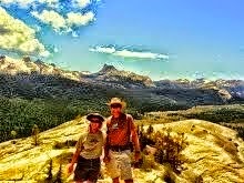
The next day we scrambled nearly to the top of a ridge
in Red Canyon.
Below and to the left of Judy is a natural bridge,
or window.

The window is behind and to the right of Dennis.
There is even a small window above.
This climb was off trail and very steep.

We had to get lots of pictures at the window
because the climb was tough and the colors
were unbelievable.

After the off-trail climb, we decided to hike to the top
of the ridge on the other side of the highway.
This hike started in our campground and was
just terrific.

At the end of the Buckhorn Trail.

Still at the end of the trail, just another view!

On the way back down Buckhorn Trail.

Back to Bryce Canyon and heading down the
Queen's Garden Trail. It connects with the
Navajo Loop Trail to make "the world's
best 3 mile hike"!
That quote is in the Bryce Canyon Newspaper.
The world is a large place, but this hike is great.

On the Queen's Garden Trail.

Dennis, passing through one of the
carved tunnels.

Almost to the Gardens.
What balance!
If you are waiting for pictures of the garden,
it is a ROCK garden!

Here is a ROCK carin garden.
It is near the intersection of the the Garden
and the Navajo Loop trails.

Heading up the steep switchbacks nearing the
Sunset Point Overlook and a short half-mile walk
along the rim to Sunrise Point and our car.

Last evening picture at Sunset Point.

In the Grand Staircase Escalante NM
We drove 10 miles on a dirt road (Cottonwood) to
Grosvenor Arch.

We had a great walk around parts of the base but did
NOT attempt to climb any part.

Fifteen miles on a beautiful dirt drive gets us to
the Cottonwood Narrows Trail. We started at the
north end and finished at the south.

Some places were only about 10 feet across, but most
were not that narrow.

Multicolored rock formations and a great
hiking partner.

Again.

Resting at the south end of the trail.
The Cottonwood Narrows begins just behind Judy.

We walked the road back to the car for different
views of the canyon.

Cottonwood Road runs about 50 miles from Hwy 89
near Big Water, UT to Hwy 12 in Cannonville.
Nearly all of the road is in the Grand Staircase
and usually passable by passenger cars.
However, all of the cars are red upon exit!

No comments:
Post a Comment