Route through CA.
We spent 4 days exploring this park in the
Sierra Nevada mountains. John Muir's
work (and others) on the preservation of this area
is the basis for the National Park system.
However, it was the 2nd park established in the US.
Yellowstone was first.
This is the view as you enter the valley
at Tunnel View--just like the sign!
The Sierra Nevada is a single piece of granite
that has been (and continues to be) uplifted,
weathered, glaciated, and eroded.
Evening in the valley with Half Dome
reflected in the Merced River.
Same evening looking in the other direction
at Upper and Lower Yosemite Falls!
The total fall including the (not visible)
cascade is 2425 feet. It is the highest
falls in North America.
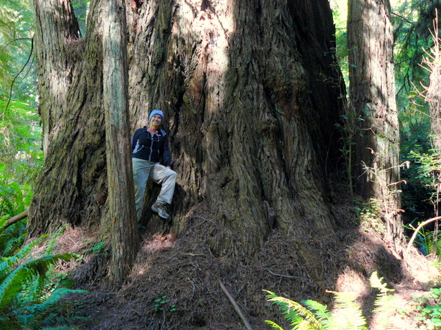
Our first walk was to and through the
Tuolumne Grove of Giant Sequoias.
These trees are the most massive living thing anywhere.
This one was tunneled in the 1800's and has since died.
Another fallen tree. This one has Judy posing
on it where the diameter is at least 8 feet.
I took the picture 55 big steps from her.
A smaller live Sequoia.
The Pacific Dogwoods were in full bloom.
Judy climbing on another downed tree with
a dogwood bloom in the foreground.
The tunnel tree.
The entrance to the Hetch Hetchy valley portion
of the park. After the fires in San Francisco in the
early 1900's and the massive destruction due to poor water service,
a dam was built to provide dependable clean water to the city.
It flooded a valley similar to Yosemite.
The dam was built after Yosemite was a
National Park and the legislation was passed
when John Muir was away.
The reservoir from the dam.
The water is about 360 feet deep here.
On the hike to Wapama Falls.
At the bottom you can see lots
of mist from the falls.
Traditional pose above Hetch Hetchy Reservoir.
There are three groves of Giant Sequoias
in the Park. This is the Grizzly Giant
in the Mariposa Grove.
(Judy is in front, she is NOT grizzly)
Even in person,
it is hard to realize the size of these trees.
The limb on the south side of this tree
is nearly 7 feet in diameter.
That limb is larger than any other tree around.
Both of us being Grizzly!
We visited the oldest living thing
(Bristlecone pine), the most massive living thing
(Giant Sequoia), and in a couple of weeks,
we will visit Sequoia's cousin, the Coastal Redwoods.
They are the tallest living things!
We tried to hug this tree, but. . . . .
For Tom Yost.
Snow Plants growing in the grove. They get their
essentials from fungi that are connected to tree roots.
The rest at Lower Yosemite Falls before our
12 hour day of touring and hiking.
The post card photo in the Valley with Judy
and a Western Cedar log in the foreground.
Bridalveil fall is nearly obscured by the trees on the right
and El Capitan, a 3593 foot monolith, stands to the left.
This is from near Glacier Point overlooking Nevada
and Vernal Falls on the right and Half Dome above my head.
Another typical pose--not even scary.
It is about 3200 feet nearly straight down
to the Valley from Glacier Point.
Fortunately, behind us is a trail.
The big hike of the day was about 6.5 miles
to Taft Point, past Sentinel Falls and to the top of
Sentinel Dome. This is near Taft Point.
The fissures near Taft Point.
At Taft Point. Just to the right of my head; you
may be able to make out a man lying on his
belly looking down those 3000 feet.
Now, this was scary!
Thank goodness that there was a rail to hold us back.
Looking down and across the Valley
at Yosemite Falls from Taft Point.
Between Taft and Sentinel Dome, Judy points out
our destination.
On the hike to Sentinel Dome.
On the hike to Sentinel Dome.
Nearly to the top.
Judy at the top of Sentinel Dome
just in time for sunset.
On the top and on a postcard tree.
I'm up there, too!
We only had a 1.3 mile hike back to the car.
Made it just before complete darkness.
We were determined to NOT do another
12 hour day of hiking--we didn't.
The Tuolumne Meadows day was only 10 hours.
Another day and we are headed to Tuolumne Meadows.
We stopped at Olmsted Point to view the Valley
from the other end. We saw marmots the same time
that this boy did.
He approached them, sat quietly, and waited.
It appears that they are more interested
in humans than he is in marmots!
Getting information for our hike to the top of
Lembert Dome.
Half way up and a photo op.
On the top of Lembert Dome, with Cathedral
Peak behind us and the Meadows below.
We decided to walk to another nearby dome and
look back to where we had been.
Dennis jumping to the next piece of granite.
It only looks scary.
We stopped in the Meadows to soak our feet and
enjoy the view. That is Lembert Dome behind us.
AHHHH, that is snow melt water. BRRRR.
On our way home, we stopped at Tenaya Lake
for happy hour, more feet soaking, and viewing.
What a view!
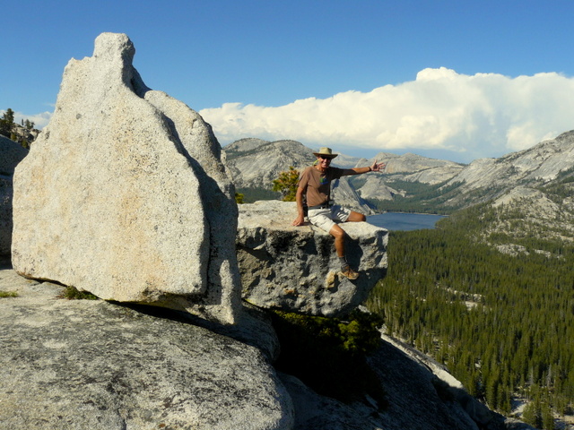
Backtracking near Olmsted Point, we found
another dome to climb.
This one overlooks Tenaya Lake.
Beautiful posing by a tree and Judy.
That piece of granite is overhanging.
It must be scary, Judy is leaning back.
Yosemite NP is very large and we put
lots of miles on the car getting around.
We are on our way now to the wine country of
Napa and Sonoma Counties.